
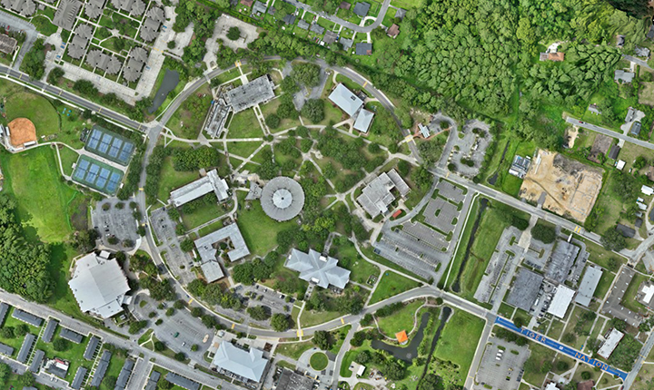
Every infrastructure decision starts with information. Where are the existing utilities? Which properties or communities could be affected? Where are assets located, and what condition are they in? How have conditions changed over time?
For public agencies, utilities, and infrastructure owners, having data is rarely the challenge. The harder question is whether that information is accurate, current, and useful enough to support a decision.
Often, organizations are working with information accumulated over decades. Knowledge may be contained in aging plans, recent engineering drawings and surveys, separate databases, or even with longtime personnel preparing to retire. Bringing those sources together and determining which information can be trusted can be a significant undertaking.
Geographic information systems (GIS) can help connect those pieces by bringing information from different sources together and tying it to location. But the map someone sees on a screen is only the end product. Behind it are decisions about how information is collected, verified, maintained, analyzed, and ultimately used.
For GIS Day, we’re looking beyond the map at an important question for anyone making decisions based on geographic data: How do you know you can trust the information in front of you?
To explore that question, we spoke with Chase Bennett, GISP, GIS Analyst/Developer, whose work across GIS, UAS, and surveying provides a firsthand view of what happens between collecting information in the field and putting it to use.
A Map Is Only as Useful as the Information Behind It
GIS can bring together layers of information that might otherwise live in separate databases, spreadsheets, drawings, field records, or systems. Viewing those layers together can reveal relationships that are difficult to recognize when each source is considered separately.
But putting information on a map does not automatically make it reliable.
Some of the most common problems are relatively straightforward: the information is old, metadata is missing, coordinate systems or projections do not match, or datasets were created to different standards of accuracy. Survey-grade data, for example, should not be treated as interchangeable with information developed for conceptual planning.
Determining whether information is reliable therefore requires more than checking whether it looks right on the screen. Does it check against known control? Does it align with data collected independently or by a third party? Is there a clear chain of custody? Is there sufficient metadata explaining the source, collection method, age, and intended purpose? And how reliable has that source historically been?
Those questions become particularly important when the information will support infrastructure planning, asset management, emergency response, capital investment, or other consequential decisions.
There is another complication: the real world keeps changing.
With utility and topographic data, grading, construction, demolition, and the relocation of infrastructure can make an existing dataset outdated surprisingly quickly. On multiple occasions, aboveground utilities have been located in the field only to be removed or relocated the following day. In an even more striking example, a catch basin was located in the field and demolished roughly 15 minutes later.
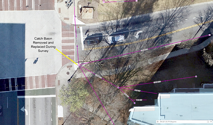
Utility systems are dynamic networks. Even accurate information represents conditions at a particular point in time, making the processes used to maintain, verify, and understand that information just as important as the original data itself.
What Happens Before Information Reaches the Map?
The finished map may look simple. The work behind it often is not.
When developing or updating a GIS, the process can begin by collecting all available sources and bringing them into a common geodatabase and coordinate system. Overlapping or conflicting records then have to be evaluated, with higher-quality sources, such as as-built or construction documents, generally prioritized over conceptual information or data from unknown sources.
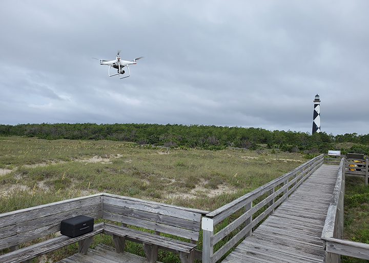
The process can extend into the field as well. High-resolution unmanned aerial system (UAS) imagery may be collected and site control established. Traditional and GPS surveying can then be used to evaluate conditions and locate aboveground and underground utilities. The resulting information goes through quality assurance and quality control to identify logical gaps and other potential problems.
Throughout that process, one question remains central: Does this information meet the client’s needs for the task at hand?
Once the answer is yes, there is still an important step remaining: reviewing the information with the client personnel who know the systems being mapped best. Their institutional knowledge can provide important context that a drawing, database, or field observation alone may not reveal.
No dataset will ever be 100 percent accurate. The goal is to understand the quality and limitations of the information well enough to be confident in how it is being used.
For someone who only sees the finished map, one of the most surprising aspects may simply be the amount of time and manual effort required to thoroughly check and correct the information behind it.
When Better Information Changes the Decision
The value of GIS is not simply the ability to produce a better map. Its value comes from what people can do when different sources of information are brought together and analyzed.
A project at Emory University’s Oxford Campus in Oxford, Georgia, demonstrates how significant that can be.
During a sanitary sewer CCTV assessment, a field crew encountered a damaged sewer line beneath a campus parking lot. The inspection provided one key piece of information: the distance from the upstream manhole to the point where the line had failed.
Using GIS data developed during a utility mapping effort, the team measured that distance along the sewer alignment. That analysis identified a fiber optic line crossing the sewer at the same location as the damage. Further investigation revealed that the existing sewer line had been inadvertently bored through during installation of the fiber line, which had been placed at approximately the same depth.
But another source of information added to the picture.
Because the campus had also been surveyed using high-resolution UAS imagery, the team was able to review aerial data from the location. Visible cracking could be seen in the asphalt directly above the damaged utility crossing. The cracking suggested that a subsurface void or sinkhole could be developing as a result of the compromised sewer line.
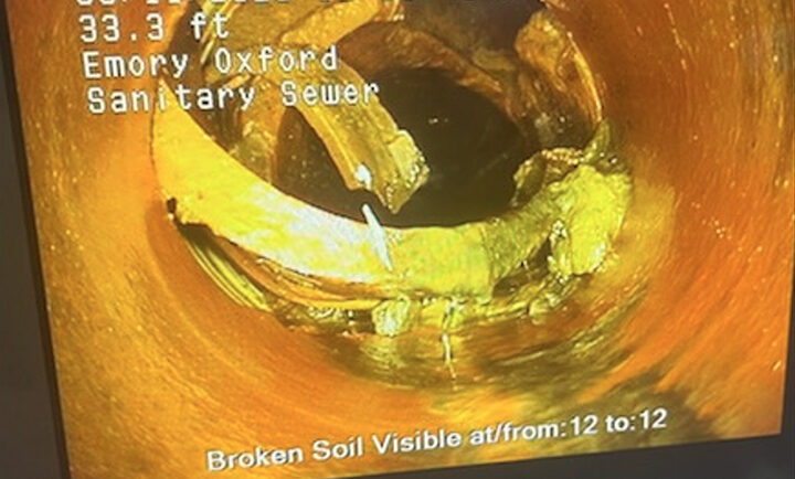
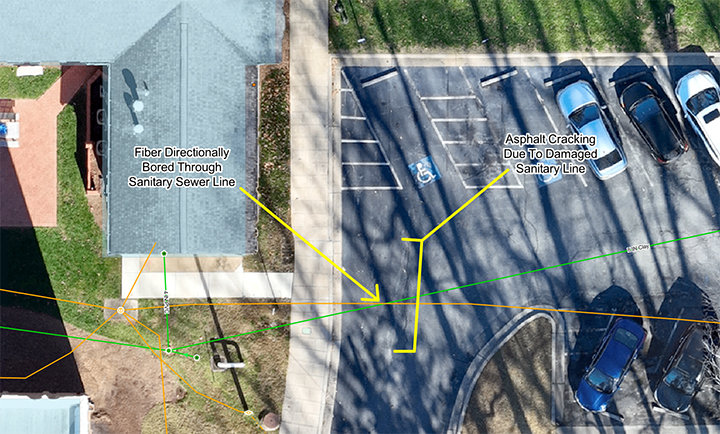
Individually, each source told only part of the story. Together, CCTV inspection data, GIS mapping, and UAS imagery allowed the team to identify the likely cause of the failure and provide campus staff with precise supporting information. That gave the university what it needed to address the issue with the appropriate parties and remediate the problem before it developed into a potentially hazardous condition for students, faculty, and visitors.
That is where GIS becomes more than mapping.
Moving From Accurate Data to Useful Information
GIS is more than locations on a map and rows in a spreadsheet. Its real value comes from analyzing and cross-referencing information from multiple sources to identify relationships that might otherwise go unnoticed.
In surveying and engineering, developing an accurate dataset can sometimes feel like the finish line. In reality, it is often only the beginning.
As Chase puts it, too often “we build the car but never take it for a drive.”
The opportunity comes from putting the information to work: asking questions, identifying problems, comparing conditions, spotting patterns, and giving decision-makers a more complete understanding of what is happening on the ground.
A GIS that simply stores information has value. A GIS that helps someone understand a system and make a better decision can have considerably more.
GIS Day: Recognizing the Work Behind the Information
GIS Day gives us an opportunity to recognize not only the technology behind geographic information systems, but also the professionals who make that information meaningful.
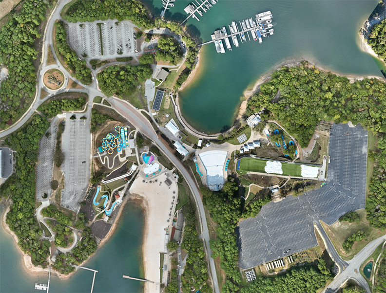
Maps and applications may be the most visible part of GIS, but much of their value comes from work that happens before the finished product appears: understanding the client’s question, collecting and evaluating information, resolving inconsistencies, verifying conditions, analyzing relationships, and communicating what the data actually shows.
Ultimately, good GIS data gives clients the ability to understand their systems as a whole, identify problems before they become emergencies, develop the right solutions when unforeseen circumstances arise, and make informed decisions that save time, conserve resources, and deliver better outcomes for both system managers and the communities they serve.
The People Behind the Work
This article was developed with insight from Chase Bennett, GISP, GIS Analyst/Developer, whose experience spans GIS, UAS, and surveying, from collecting and verifying information in the field to analyzing data and developing GIS applications. That combination of field and technical experience gives Chase a firsthand perspective on a central idea behind this article: reliable information is only the beginning. Its real value comes from knowing how to put it to work.
Chase Bennett, GISP
Better Information Supports Better Decisions.
From collecting and verifying data to transforming it into actionable insight, our GIS services help clients get more value from the information behind their infrastructure.
