Dynamic Solutions

Articles

Research Spotlight: Understanding Storm Surge and Mississippi River Flows

What happens to Mississippi River flows when coastal storm surge moves upstream? DynamicSolutions | DCCM, in cooperation with Gaurav Savant at the U.S. Army Engineer Research and Development Center (ERDC), recently published a study in the ASCE Journal of Waterway, Port, Coastal, and Ocean Engineering examining the interaction between storm surge and flows on the Mississippi River. Using a fully coupled Adaptive Hydraulics Model (AdH), the study found that local discharge decreases as water levels rise with the passage of storm surge due to a shift in net momentum flux. Researchers also found that the river’s discharge response following the surge depends on the availability of lateral relief to discharge stored mass. The findings provide additional insight into the complex interaction between coastal and riverine processes and demonstrate the value of fully coupled hydrodynamic modeling for understanding these dynamic systems. Read the Full Study DynamicSolutions | DCCM combines applied research, advanced hydrodynamic modeling, and water resources engineering to help public agencies and project partners better understand complex riverine and coastal systems. Explore DynamicSolutions | DCCM’s services or connect with our team to learn how our modeling expertise can support complex water resources challenges.

Articles

Modeling Oyster Populations to Support Coastal Restoration

Each spring marks the beginning of a prominent oyster spawning season in coastal Louisiana—and another cycle in the life of an organism that plays an important role in the health of coastal ecosystems. Oysters provide a variety of ecosystem services, but their populations are in decline. Understanding how oyster populations respond to changing conditions and restoration efforts requires looking beyond individual reefs to the connections among oyster populations across an entire coastal system. DynamicSolutions | DCCM, in partnership with an interdisciplinary team of scientists from public, private, and academic institutions, is leading the development of a fully coupled, mechanistic oyster metapopulation model designed to do just that. Modeling an Interconnected Oyster Population Oyster populations do not function in isolation. Larvae can move between locations before settling and developing on reefs, connecting individual oyster reefs as part of a larger metapopulation. Capturing those relationships requires a model capable of representing processes occurring across dramatically different scales. The model being developed by DynamicSolutions | DCCM and its project partners simulates larval and oyster reef dynamics across temporal scales ranging from seconds to decades and spatial scales ranging from individual reefs to entire coastal basins. By bringing these processes together within a single modeling framework, the team is developing a tool that can help managers better understand oyster population dynamics across complex coastal systems. Supporting Data-Driven Restoration Decisions Restoring oyster populations requires decisions about where and how restoration efforts may be implemented. A modeling tool capable of representing both individual reefs and their connections across a broader coastal basin can provide another source of information for evaluating those decisions. The oyster metapopulation model is being developed to provide managers with a data-driven approach to help inform restoration efforts. By examining oyster and larval dynamics across both short- and long-term timescales, the model can support a broader understanding of how oyster populations function within Louisiana’s coastal environment. An Interdisciplinary Approach Developing a model at this scale requires expertise spanning engineering, ecology, coastal science, and resource management. DynamicSolutions | DCCM is leading the effort in collaboration with: Louisiana Department of Wildlife and Fisheries U.S. Geological Survey Louisiana State University University of Maryland Center for Environmental Science The Water Institute of the Gulf Coastal Protection and Restoration Authority Together, the interdisciplinary project team is combining scientific and technical expertise to develop a practical tool for understanding oyster population dynamics and supporting coastal restoration decision-making. DynamicSolutions | DCCM works alongside public agencies, researchers, and project partners to apply advanced modeling and water resources expertise to complex coastal and ecosystem challenges. Explore DynamicSolutions | DCCM’s services or connect with our team to learn how our modeling expertise can support ecosystem restoration, coastal resource management, and data-driven environmental decision-making.

Articles

Understanding a Changing Mississippi River During Historic Low Flows

The Mississippi River is a dynamic system, continually responding to changes in flow, sediment, climate, and human activity. During periods of extreme low flow, those changes can become particularly visible—and their impacts can extend far beyond the river channel itself. During a period of severe drought across portions of the Great Plains, Ohio Valley, and Lower Mississippi River Valley, the Mississippi River reached historic low levels. The conditions affected navigation and sedimentation throughout the river system while contributing to another challenge hundreds of miles downstream: the progression of saltwater upstream from the Gulf of Mexico. For DynamicSolutions | DCCM, these conditions provided a firsthand look at the complex processes continually reshaping one of the nation’s most important waterways. Studying Sedimentation Near Hickman, Kentucky DynamicSolutions | DCCM engineers Christopher Wallen, Steve Sanborn, and Zach Wallen observed the effects of the low-flow conditions while beginning a sedimentation study near Hickman, Kentucky. Sediment movement is closely connected to river hydraulics. Changes in flow can influence where sediment is transported, deposited, or eroded, creating implications for navigation channels and other river functions. Understanding these processes is an important part of developing sustainable approaches to managing navigation while considering the broader environmental functions of the river. When Low River Flows Affect Drinking Water The impacts of unusually low Mississippi River flows were also being experienced much farther downstream. Under low-flow conditions, reduced freshwater discharge allowed a saltwater wedge from the Gulf of Mexico to progress upstream along the Lower Mississippi River, affecting drinking water supplies downstream of New Orleans. DynamicSolutions | DCCM’s Dr. William McAnally provided insight into the phenomenon for The Atlantic, helping explain the river processes contributing to the movement of saltwater upstream. The event illustrates how conditions occurring across the Mississippi River watershed can create interconnected effects spanning hundreds of miles—from sedimentation and navigation challenges upstream to water supply concerns near the Gulf Coast. Understanding a River That Is Always Changing Change is one of the defining characteristics of the Mississippi River. Its flows, sediment, channels, and surrounding ecosystems continually respond to natural and human influences. Periods of extreme high or low water can amplify those changes and create new challenges for the communities, industries, and ecosystems that depend on the river. Through sedimentation studies, hydraulic analysis, modeling, and river engineering, DynamicSolutions | DCCM works to better understand these changing conditions and develop sustainable solutions that support both navigation and ecosystem services. DynamicSolutions | DCCM works alongside public agencies and project partners to understand complex river systems and develop practical solutions for navigation, sediment management, water resources, and ecosystem needs. Explore DynamicSolutions | DCCM’s services or connect with our team to learn how our river engineering and modeling expertise can support resilient, sustainable water resources solutions.

Articles

Mixing Zone Studies: When Simpler Modeling Is the Better Approach

When it comes to water resources modeling, more complex does not always mean more appropriate. The processes governing the behavior of discharge plumes can be highly complex. Understanding how an effluent mixes with receiving waters may require consideration of discharge characteristics, ambient conditions, plume behavior, and other factors. While computational fluid dynamics (CFD) modeling can provide a detailed representation of these processes, not every mixing zone study requires that level of complexity. For many applications, the Cornell Mixing Zone Expert System (CORMIX) provides a practical alternative. Simplifying Complex Plume Analyses DynamicSolutions | DCCM engineers have recently applied CORMIX to several mixing zone studies. The modeling system uses a rule-based flow classification approach to predict steady-state mixing behavior and simulate plume geometry. Rather than explicitly modeling the full three-dimensional flow field, CORMIX classifies a discharge based on the characteristics governing its behavior and applies the appropriate analytical framework to evaluate mixing. This approach allows engineers to assess complex discharge plume behavior without immediately turning to a more computationally intensive CFD model. One Tool, Many Discharge Types Mixing zone analyses are relevant to a wide range of facilities and discharge conditions. CORMIX can be used to simulate discharge types including municipal wastewater, desalination facility outflows, drilling rig brines, and power plant cooling waters. Although the characteristics of these discharges can vary considerably, each presents a similar fundamental question: How will the discharged water mix with the receiving water? Selecting an appropriate modeling approach helps engineers evaluate that question at a level of detail that aligns with the needs of the study. Matching the Model to the Question DynamicSolutions | DCCM engineers enjoy developing detailed CFD models when a project calls for them. But sophisticated modeling should serve the project—not add complexity simply for complexity’s sake. For mixing zone studies where CORMIX can appropriately represent the discharge and receiving-water conditions, a streamlined modeling approach can provide the information needed to understand plume behavior without requiring a more complex CFD analysis. The key is selecting the modeling tool that matches the technical question, available data, and required level of analysis. DynamicSolutions | DCCM helps public agencies, utilities, and project partners select and apply appropriate modeling approaches for complex water resources and water quality challenges. Explore DynamicSolutions | DCCM’s services or connect with our team to learn how our modeling expertise can support mixing zone studies, discharge analyses, hydrodynamic modeling, and water quality projects.

Articles

Evaluating the Effects of Groundwater Seepage on Everglades Water Quality

Understanding the sources and movement of phosphorus is an important part of managing water quality within the Everglades ecosystem. Stormwater Treatment Areas play a key role in these efforts, making it important to understand the factors that may influence phosphorus concentrations in water leaving these systems. DynamicSolutions | DCCM Modeling Director Silong Lu, Ph.D., P.E., D.WRE, recently shared research examining one of those potential factors: vertical groundwater seepage. Dr. Lu presented the findings at the Greater Everglades Ecosystem Restoration (GEER) 2023 conference. The work, completed with the South Florida Water Management District, evaluated the effects of vertical groundwater seepage on outflow phosphorus concentrations within Everglades Stormwater Treatment Areas. Understanding a Potential Source of Phosphorus Water quality within a complex system like the Everglades can be influenced by numerous interconnected processes. Determining the relative contribution of individual phosphorus sources can help water resource managers better understand treatment performance and focus attention on the factors having the greatest influence on water quality. As part of this work, Dr. Lu evaluated whether vertical groundwater seepage represented a significant contributor to phosphorus concentrations at the modeled Stormwater Treatment Areas. The findings suggest that, under typical loading scenarios, vertical groundwater seepage is not a significant factor in outflow phosphorus concentrations at the modeled areas. Informing Everglades Water Quality Management Understanding which processes have—and do not have—a significant influence on phosphorus concentrations provides valuable context for water quality management. The findings help clarify the relative contribution of groundwater seepage compared with other potential phosphorus sources within the modeled Stormwater Treatment Areas. This information can support a more complete understanding of how these important Everglades water quality mitigation features perform and the processes influencing their outflow concentrations. Research and modeling efforts such as this provide water resource managers with additional information for evaluating complex environmental systems and supporting ongoing Everglades restoration and water quality initiatives. DynamicSolutions | DCCM works alongside public agencies and water resource partners to apply advanced modeling and technical analysis to complex water quality, hydrologic, and ecosystem challenges. Explore DynamicSolutions | DCCM’s services or connect with our team to learn how our modeling and water resources expertise can support water quality management, ecosystem restoration, and environmental decision-making.

Articles

Understanding Compound Flooding Through Integrated Modeling

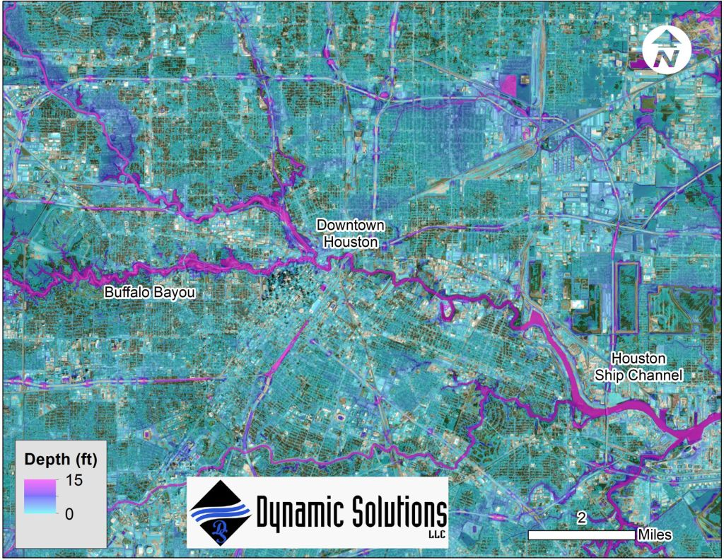
When a coastal storm makes landfall, which poses the greater flood risk: heavy rainfall or storm surge? The answer can be both. Coastal communities can experience multiple sources of flooding simultaneously. Storm surge pushes water inland while heavy rainfall generates runoff and increases riverine flows. Where these processes interact, the resulting compound flooding can create complex—and potentially devastating—conditions that cannot be fully understood by looking at each source independently. Accurately representing those interactions presents an important challenge for engineers and flood risk managers. The Challenge of Modeling Compound Flooding Historically, compound flooding has often been simulated by loosely coupling a hydrologic/hydraulic watershed model with a separate coastal storm surge model. Each model represents an important component of the overall event, but separating those processes can make it difficult to fully capture the nonlinear interactions among rainfall-runoff, riverine flows, and storm surge. The U.S. Army Engineer Research and Development Center (ERDC) developed an advanced version of the Adaptive Hydraulics Model (AdH) specifically to address this challenge. Unlike approaches that model individual flood sources separately, AdH can simulate rainfall-runoff, riverine flows, and storm surge together in a single, monolithic simulation. This allows the model to directly represent how multiple flood sources interact as conditions change throughout an event. Simulating Hurricane Harvey in Harris County DynamicSolutions | DCCM used the advanced version of AdH to perform a monolithic simulation of flooding in Harris County, Texas, during Hurricane Harvey. The analysis identified a 37-kilometer-long compound flooding transition zone within Buffalo Bayou where multiple flood sources interacted. Within a transition zone such as this, flooding cannot necessarily be attributed solely to rainfall, riverine flow, or coastal surge. Instead, water levels reflect the combined and nonlinear effects of multiple processes. A monolithic modeling approach allows these interactions to occur within the same simulation, providing a more complete representation of the resulting water levels and flood conditions. Looking Beyond Historical Events The value of compound flood modeling extends beyond recreating—or hindcasting—past storms. AdH can also be used to run stochastic coastal storm simulations to evaluate flood risk in coastal areas vulnerable to compound flooding. Rather than focusing solely on what occurred during a single historical event, these simulations can help evaluate potential flooding across a range of storm conditions. For communities where coastal surge, river systems, and rainfall-driven runoff converge, understanding these interactions can provide important information for flood risk assessment, infrastructure planning, and resilience efforts. As flood hazards become increasingly complex, the modeling tools used to understand them must be capable of representing that complexity. Integrated approaches such as AdH provide engineers and public agencies with a way to evaluate multiple flood mechanisms as the interconnected processes they are. DynamicSolutions | DCCM helps public agencies and project partners understand complex flood processes through advanced hydrodynamic modeling and water resources engineering. Explore DynamicSolutions | DCCM’s services or connect with our team to learn how our modeling expertise can support compound flood analysis, coastal and riverine flood risk assessment, and resilient infrastructure planning.

Articles

Advancing Compound Flood Modeling with an Integrated Approach

Flooding rarely occurs from a single source. During major storm events, heavy rainfall, riverine flooding, and coastal storm surge can occur simultaneously, creating compound flooding conditions that are more complex—and potentially more damaging—than any individual flood process. Understanding how these processes interact is critical to accurately estimating flood hazards and supporting resilient infrastructure planning. Yet, traditional modeling approaches often evaluate individual flood sources separately and then combine the results. While useful for certain applications, this approach may not fully represent the interactions occurring between rainfall, rivers, and coastal systems during an extreme event. DynamicSolutions | DCCM recently collaborated with the U.S. Army Engineer Research and Development Center (ERDC) to advance a more integrated approach to compound flood modeling. Capturing Multiple Flood Processes in a Single Model The project involved implementing an advanced version of the Adaptive Hydraulics Model (AdH) capable of simulating the combined impacts of heavy rainfall, riverine flooding, and coastal storm surge within a single modeling framework. By representing these processes together, the model can account for interactions that may be missed when individual flood sources are modeled independently. This provides a more integrated representation of how water moves through interconnected coastal and riverine environments during major storm events. The approach is particularly valuable in areas where rainfall-driven runoff, river flows, and coastal water levels can influence one another and contribute collectively to flood conditions. Applying the Model to Hurricane Harvey To demonstrate the advanced modeling capabilities, DynamicSolutions | DCCM and ERDC applied the model to Hurricane Harvey in Galveston Bay and Harris County, Texas. Hurricane Harvey provided an opportunity to evaluate a complex event involving multiple sources of flooding across a large coastal and urban environment. Using the advanced version of AdH, the team simulated the combined influence of heavy rainfall, riverine flooding, and coastal storm surge within a single model. Rather than treating these mechanisms as isolated processes, the integrated approach allowed their interactions to be represented directly within the simulation. Improving Our Understanding of Compound Flood Risk As communities plan for extreme weather and changing flood risks, understanding compound flooding is increasingly important. Flood hazard assessments that better represent the interaction among multiple flood sources can provide engineers, planners, and public agencies with more complete information for evaluating vulnerabilities and planning infrastructure improvements. Integrated modeling approaches such as this can help advance the way complex flood events are analyzed—providing a more comprehensive picture of how rainfall, rivers, and coastal systems work together during extreme conditions. DynamicSolutions | DCCM brings specialized expertise in hydrodynamic modeling and water resources engineering to help public agencies and project partners better understand complex flood processes and evaluate infrastructure challenges. Explore DynamicSolutions | DCCM’s services or connect with our team to learn how our modeling and water resources expertise can support flood risk assessment, resilient infrastructure planning, and complex water resources projects.

Articles

A Practical Approach to Sediment Transport Modeling

Sediment transport modeling can be an important tool for understanding how waterways respond to changes in flow, channel geometry, and proposed improvements. However, comprehensive numerical sediment modeling can also require significant data collection, computational effort, and budget. For many projects, particularly during early planning and alternatives development, that level of analysis may not be necessary. A more targeted approach can provide valuable insight while allowing project teams to focus resources where they will have the greatest impact. Using Hydrodynamic Modeling to Inform Sediment Assessments DynamicSolutions | DCCM recently applied this approach for a U.S. Army Corps of Engineers (USACE) study on the Arkansas River. Rather than beginning with a comprehensive numerical sediment transport model, our team leveraged results from an existing two-dimensional (2D) hydrodynamic model to estimate sediment transport capacity through a problem reach. The hydrodynamic model provided information about hydraulic conditions within the reach that could be evaluated in the context of sediment movement. Using these results, our team developed estimates of sediment transport capacity and assessed how proposed changes could influence conditions within the study area. Supporting Efficient Alternatives Screening The analysis provided a practical way to screen alternative designs for navigation improvements without immediately undertaking a more extensive sediment modeling effort. This type of approach can be particularly useful during early project phases, when the primary objective is to understand relative differences among alternatives and identify concepts that warrant further investigation. By using available hydraulic information to evaluate sediment transport behavior, project teams can narrow the range of alternatives before investing in more detailed analyses. It also allows the level of modeling effort to better match the decisions being made. If an initial assessment identifies significant sediment-related concerns or uncertainties, more comprehensive sediment transport modeling can then be focused on the alternatives and locations where additional detail is most valuable. Matching the Analysis to the Project Sedimentation studies do not always require the most complex modeling approach from the outset. The appropriate methodology depends on the project objectives, available data, site conditions, and level of detail needed to support decision-making. For the Arkansas River study, leveraging 2D hydrodynamic model results provided an efficient means of estimating sediment transport capacity and screening navigation improvement alternatives. The result was a focused analysis that provided useful technical information while recognizing the data, schedule, and budget considerations associated with more comprehensive numerical sediment modeling. By selecting an analytical approach that matches the questions a project needs to answer, engineers can provide meaningful sedimentation insights while reserving more intensive modeling efforts for situations where they are truly warranted. DynamicSolutions | DCCM helps public agencies and project partners apply practical, data-driven approaches to complex water resources challenges—from hydrodynamic and sediment transport modeling to navigation, river engineering, and waterway improvements. Explore DynamicSolutions | DCCM’s services or connect with our team to learn how our water resources expertise can support your next project.

Articles

Unnatural Wonder: Colorado River

This spring DynamicSolutions | DCCM’s own Steve Sanborn joined a Colorado River trip through the Grand Canyon. On the trip happened to be two journalists from The Arizona Republic working on a story about the effects of regulated flows on the Colorado River’s ecosystem. The reporters put together a great story and video, which uses footage and thoughts from Steve’s trip, about the challenges the river faces and efforts to revitalize the ecosystem. “A river once wild, muddy and warm now flows cold and clear, every drop measured out to supply cities and farms downstream. Water levels ebb and flow hourly, erasing the spring surges and summer droughts innate in desert rivers. Scientists manage nature’s cycles, adding what was lost, nursing what remains.” Read the Article

Scroll to Top